Project Description
 |
 |
The Roman frontier in North-Western Romania is one of the few physical barrier and one of the greates monuments of Romania' heritage, similar to those from Britain and Germany included on WHS list.
One of the Culture 2000 projects to safeguard archaeological heritage (Frontiers of the Roman Empires - FRE project) include theoretically also the territory of the province Dacia and established the framework within which the ideas could be developed and accomplished. Nevertheless, the former attempts of the Romanian archaeologists to integrate also the Roman limes of Dacia were annihilated from various reasons, the most important financial, however the late Al.V. Matei have tried his best to include the part of the Roman heritage of Romania in the project. It has been almost nothing done and the basic state of research or detailed recordings of monuments are limited or none. Our plan is to embrace the guidelines laid down by UNESCO and ICOMOS and finally to make the first steps for the integration of the classical heritage of north-western Romania in the WHS list.
For the integration in the WHS list the World Heritage Comitee must be ensured that the monuments are adequately recorded, protected, conserved and presented, finaly properly managed. In order to help this process and advice on archaeological matters we must first of all have a thorough understanding of the monuments.
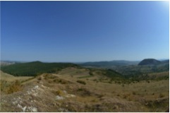
But why is the territory of North-Western Romania worth to be studied? First of all because here we have the only clear stretches of a physical barrier of the Roman empire, ramparts, ditches, towers or fortlets, built sometimes in stone. The reasons for these real frontiers are not clearly understood, but it began to be proven the extraordinary dynamic of population in North-Western Romania. This is due to the landscape, a perfect area for agriculture and therefore habitation, where Pannonian Plain is bounded by the Carpathians mountains, with unparalleled opportunities to study the ancient landscape and population. Here has been a formidable development of different cultures and population from Neolithic to the Modern times. The Romans fastened the limits of the Roman empire at one time in the area of nowadays Moigrad ( the ancient Porolissum), but there are signs that at first they have tried to control also the Northwestward zones. The real motivation is apparently blind, but the landscape would be the point.
The study of the roman limes is not something new, but one of the first preoccupations of the scholars in the roman archaeology field. The study of the roman borders is extremely advanced at international level, but, against this fact, the logic of the roman defensive system as a whole is not yet fully understood. There are no doubts that the defensive system depends of the moment when it was built and of the local conditions found by Romans in the areas where they settled. The decision to set a limit on certain place depends of the conditions arise in their route and of the world beyond the future border. So, first has to be established the limit as far as the Romans reached and then detected the reasons which determined them to set up an artificial border.
The most spectacular part of the roman frontier is the so-called Hadrian's Wall, a wall built in stone in the first half of the IInd century as an artificial frontier laying from one coast of the British isthmus to the other on a 80000 feet length, which had "to separate the Romans from barbarians" as the Hadrian's biographer wrote himself in the emperor's biography. The Romans usually preferred the places where they could use the natural frontiers and when they were moving forward they have done it for very strong reasons. Having only few ancient literary sources, these reasons are least understood. Artificial borders were also discovered in Germany or in Africa, being now still in study under an interdisciplinary effort.
The limits of the Roman Dacia are relatively clear in the specialized literature, with only few indefinite matters concerning the western frontier. However, the monuments were never recorded properly with only one exception, the fort at Moigrad (Porolissum). Additionaly, recently, as a result of some information discovered in the XIXth century literature as well, it is reported another frontier in the northern and western side of the province of Dacia, at tens of kilometers beyond the existing frontier. Some few archaeological prospections were done here, confirming in this way what the history enthusiasts of the XIXth century noticed on the field. These information and succinct archaeological results are comprised in the study of Al. V. Matei and R. Gindele, Roman defensive system from north-western part of Dacia. Field researches at Supuru de Campie (Satu Mare county) and literary sources, In: Dacia Augusti Provincia, Bucuresti, 2006, 181-206.
On the places where the defensive system is clearly established can be found an evident line of demarcation: earth wall with obstacle trench (in Germany and Scotland) or stone wall (England).In Romania, on the territory of the former Roman province, such clearly defined border between Roman Empire and "the world from the other side" (barbaricum) or as provincial delimitations were not discovered on long distances and the reason is that such an analysis with modern methods is lacking us.
Therefore, the Roman limes is Romania's largest archaeological monument. The limes is an artifical barrier or demarcation line separating the Roman empire from the Barbarian world between the 2nd and the 3rd C. Along the limes there are many forts, watch-towers, fortlets, settlements, watch and transport routes and the Limes is the symbol of Europe's Roman epoch. We will try to record and study in detail all of this monuments, most of them only talked about but never recorded and studied properly.
The Roman limes is important, as it marks the frontier between the advanced Roman civilization and the so called Barbaricum-the tribal societies outside the borders, but the archaeological monuments are inseparable from the history to which it bears witness and from the setting in which it occurs therefore the study of the classical antiquity as an entity of an established area should be comprehensive, that is why the Dacian archaeological monuments should be included as the Dacians inhabited the area at the conquering time. We are de sum of cultural, social and affective experiences that influenced our existence.
It is obvious that Dacia, one of the most militarized provinces, was created beyond any natural frontiers, in the very heart of the barbaric world. That's why the understanding of conquests reasons and the knowledge of province's expanse can be extremely relevant for the general study of Roman Empire and for its military and administrative-territorial history. But, until now it was not identified any artificial un-interrupted barrier. And that's because the territorial limits of Decebalus' kingdom are not known as well. We don't know the line of Dacian fortresses founded under the rule of Dacian king that must have been conquered by Trajan then.
Establishing the territorial limits of Dacia depends now upon more advanced techniques then before. This thing is impossible to be done in the classical way (archeological excavation), who involves high costs and a long time. Establishing Dacia's topography and the topography of every archeological site with modern means and in "real time" appear as optimum solutions for saving what is left from one of the most spectacular stages of our past.
The roman defensive system in north and north-west part of Dacia has been established by the Romanian archaeologists, especially N. Gudea and Al.V Matei, following the line of Roman fortifications and of some watchtowers. The border started from Bologa-Negreni (the Cluj county) in the west, reached on the ridge of Meses, the most important strategic point, at Porolissum (Moigrad, the Salaj county), continued to the east on the line Tihau (the Salaj county), Casei (the Cluj county), Ilisua (the Bistrita-Nasaud county), Livezile (the Bistrita-Nasaud county). From here the border continued on the west side of the Oriental Carpathians. Thus it was supposed that the last Dacian fortifications were on this line somewhere. But there were Dacian fortresses towards north-west as far as the edge of the Pannonian plain or even in nowadays Ukraine at Malaja Kopanja, many kilometers away of the settled border. Why this territory should have been left unoccupied by Romans?
The existence of earth wall (the so-called "Sarmatic wall") in the west and north-west Romania or on the territories of Hungary and Ukraine is certain. Probably they are not all contemporary as long as some have adjacent ditches positioned toward former Dacia and others toward Barbaricum.
The XIXth century literature abounds in notes regarding the earth walls, but many comments report just simple draining channels, tranches from the IInd World War or natural ravines. Anyway some authors ascertain that the province had been larger, initially at least. In the XIXth century K. Torma and then V. Russu, a geography teacher, described a "valum externum" or a "limes Dacicus externus" as starting "from the Crisiul Repede, Urbea-mare (Ulpianum= nowadays Oradea), through: Bihorea, Cetari, Siteriu, Misca, over Bercau at Dida, Almasiu, on the Veratec Valley, the hill of Porcaret and of Cetate, from Cehal, on the Ursoiu to Cetatia on the periul Saldubitei at Blidaru from Divoraga and the Magia Valley to the fortress of Hodod and on the Seleagiu as far as Somes and Lapus. And this is just a sample from the records of the XIXth centurys history enthusiasts. Another source identifies even more precisely toponyms and stream names to describe the wall direction that crossed from Oradea as far as Maramures, at Lapus, its curve line touching the former fortress of Malaja Kopanja in present Ukraine. In the region of Crisul Alb and Crasna the earth walls are even named Trajans wall".
The wall can be tracked "in the county of Bereg (Ukraine), on the ridge that separate the southern lowland from the mountainous chain of north-east (The Woody Capathians)... on a line of many miles". Also in XIXth century, K. Torma, mentioning earlier sources, asserts a possible relation between "the devil's ditches or walls" (Csorsz arka from Hungaria) and "limes Dacicus", trying to demonstrate the existence of a "Regio Trans Vallum".
The information regarding earth walls have been archaeologically examined only in the last years through a few archaeological prospections accomplished in the area of Supuru de Sus village (the Satu Mare county). The wall and the ditch discovered here are about 50 kilometers away of the Roman Dacia's known border. Here the ditch closes the valley of Crasna at the place where this comes down to the plain. In the same area was identified a fortification with earth enclosure as well, belonging to the roman age probably. Therefore, the Roman Dacias territory in a first stage has been much larger.
Quite a number of ancient sources tackle with the ancient enviroment, to mention here just Pliny, Xenophon, Theophrastos (the father of botany), Demosthenes, Columella, Siculus Flaccus or Strabo, important to understand the ancient way to rely on the nature.
Ideas about how to explore and re-enact the ancient landscapes have changed considerably since Bradfords pioneering work. Now we have a much better understanding of the human, climatic, ecological, and geomorphological processes involved in the creation and deterioration of landscapes,therefore the ancient environment could be deduced. By all means, only when someone understand the landscape he will make sense of the reasons for setting out a settlement, fort or structure in a place or another. Ancient environment did rely on the landscape, more than the modern ones which are depending on the bulldozer which inevitably degrade the environment. But stones don't speak by themselves and they can not be protected if do not know where they are.
Any conservation, management and/or display of the patrimony must be based on scientifically substantiated evidence, for the complete comprehension of a monument. The limited state of knowledge of the archaeological monuments is a fact for Romania in general. We are obliged to make some changes as a preparatory research for inclusion of the Roman limes on the UNESCO WHS list. We can save only what we know. Not all of the monuments can be saved, as many are very exposed, but we have at least to record them scientifically.